
Goygol District topographic map
Interactive map
Click on the map to display elevation.
Goygol District
Goygol and 7 identical lakes – Maralgol, Zaligol, Aghgol, Shamligol, Ordekgol, Jeyrangol and Garagol are located in the territory of Goygol district. Lake Goygol is situated on the foothill of Mount Kapaz at an altitude of 1556 meters. The length of the lake is 2450 meters, and its width is 595 meters, the deepest point is 95 meters.
About this map
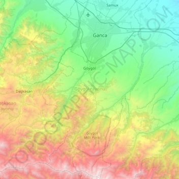
Name: Goygol District topographic map, elevation, terrain.
Location: Goygol District, 2500, Azerbaijan (40.27882 46.10809 40.77696 46.52181)
Average elevation: 1,217 m
Minimum elevation: 133 m
Maximum elevation: 3,697 m
Other topographic maps
Click on a map to view its topography, its elevation and its terrain.
Guba
Quba (Guba) is a city and the administrative centre of the Quba District of Azerbaijan. The city lies on the north-eastern slopes of Shahdag mountain, at an altitude of 600 metres above sea level, on the right bank of the Kudyal river. It has a population of 47,200 (2023).
Average elevation: 623 m
Khankendi
Stepanakert is located on the Karabakh plateau, at an average altitude of 813 m (2,667 ft) above sea level.
Average elevation: 862 m
Shamakhi
Shamakhi is located in the central part of Shirvan, at an altitude of about 749 m (2,457 ft) above sea level, in a favorable geographical position. In the south of Shamakhi flows to Zongalavay, and in the east Pirsaatchay. The city is surrounded by Binasli, Gushhan from the north, Pirdiraki, and Maiden…
Average elevation: 723 m