Geolocate

Garner topographic map

Click on the map to display elevation.

About this map

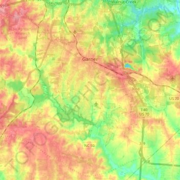
Name: Garner topographic map, elevation, terrain.

Location: Garner, Wake County, North Carolina, United States (35.64401 -78.70052 35.73131 -78.53157)

Average elevation: 94 m

Minimum elevation: 46 m

Maximum elevation: 137 m

Other topographic maps

Click on a map to view its topography, its elevation and its terrain.

New Hill

United States > North Carolina > Wake County > Apex

Average elevation: 93 m

Raleigh

United States > North Carolina > Wake County

Average elevation: 126 m

Gear up for your next adventure:

🩹First Aid Kits - Emergency kits for hiking
🦘Outback Survival Gear - Essential gear for Australian outback
📸Action Cameras - Record your journey across interesting topographic features in 4K
🕶️Polarized Outdoor Sunglasses - Reduce glare from rocks and water for better visual navigation
🦶Orthotic Hiking Insoles - Extra arch support for long-distance topographic treks

As an Amazon Associate, this site earns from qualifying purchases at no extra cost to you.