
Dakota County topographic map
Interactive map
Click on the map to display elevation.
About this map
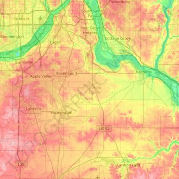
Name: Dakota County topographic map, elevation, terrain.
Location: Dakota County, Minnesota, United States (44.47118 -93.32983 44.92329 -92.73220)
Average elevation: 278 m
Minimum elevation: 188 m
Maximum elevation: 374 m
Other topographic maps
Click on a map to view its topography, its elevation and its terrain.
Fort Snelling State Park
United States > Minnesota > Dakota County > Eagan
Fort Snelling State Park, Eagan, Dakota County, Minnesota, United States
Average elevation: 246 m
Lake Rebecca
United States > Minnesota > Dakota County > Hastings
Lake Rebecca, Hastings, Dakota County, Minnesota, United States
Average elevation: 230 m
Eagan
United States > Minnesota > Dakota County > Eagan
Eagan, Dakota County, Minnesota, United States
Average elevation: 267 m
Roseport
United States > Minnesota > Dakota County > Inver Grove Heights > Roseport
Roseport, Inver Grove Heights, Dakota County, Minnesota, United States
Average elevation: 272 m
Lilydale
United States > Minnesota > Dakota County
Lilydale, Dakota County, Minnesota, United States
Average elevation: 257 m
Rosemount
United States > Minnesota > Dakota County
Rosemount, Dakota County, Minnesota, 55068, United States
Average elevation: 287 m