Geolocate

Hofu topographic map

Click on the map to display elevation.

About this map

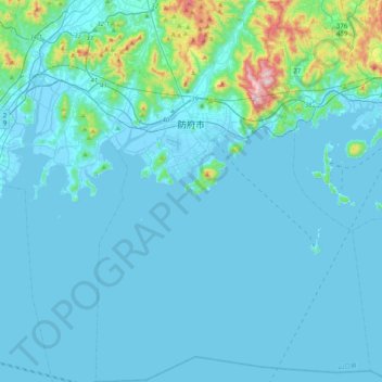
Name: Hofu topographic map, elevation, terrain.

Location: Hofu, Yamaguchi Prefecture, Japan (33.82342 131.45524 34.16048 131.75407)

Average elevation: 50 m

Minimum elevation: -5 m

Maximum elevation: 609 m

Other topographic maps

Click on a map to view its topography, its elevation and its terrain.

Akaishi Mountains

Japan > Oshika

Average elevation: 2,591 m

葭町

Japan > Matsumoto

Average elevation: 616 m

Osaka Prefecture

Japan

Average elevation: 188 m

Nakauonuma County

Japan

Average elevation: 605 m

Nishikigaoka-chuo Park

Japan > Sendai

Average elevation: 197 m

Takeda Castle

Japan > Asago

Average elevation: 174 m

Iwo to

Japan > Tokyo > Ogasawara

Average elevation: 0 m

300M

Japan > Nagasaki

Average elevation: 220 m

Mount Yatsugatake viewpoint

Japan > Suwa County > Fujimi

Average elevation: 1,742 m

Yokohama

Japan > Yokohama

Average elevation: 22 m

Abuta County

Japan > Abuta County

Average elevation: 147 m

Mount Piyashiri

Japan > Monbetsu County > Oumu

Average elevation: 787 m

Jigoku-dani Valley

Japan > Kamikawa County > Higashikawa

Average elevation: 1,796 m

Gear up for your next adventure:

Outdoor Coffee Makers - Enjoy quality coffee at the summit of your favorite peak
🦯Trekking Poles - Walking poles for hiking stability
🍶Collapsible Water Bottles - Save space in your pack as you consume your water supply
Survival Blankets - Emergency thermal blankets
Altimeter Barometer Watches - Outdoor watches with built-in sensors to track altitude changes and weather shifts

As an Amazon Associate, this site earns from qualifying purchases at no extra cost to you.