
Make a donation
Gear up for your next adventure:
As an Amazon Associate, this site earns from qualifying purchases at no extra cost to you.
Langenzenn topographic map
Click on the map to display elevation.
Make a donation
Gear up for your next adventure:
As an Amazon Associate, this site earns from qualifying purchases at no extra cost to you.
Langenzenn
Auf dem Stadtgebiet Langenzenns liegen 13 Grabhügel aus der Hallstattzeit (um 1200–750 v. Chr.). Dies lässt auf eine relativ dichte Besiedelung in dieser Zeit schließen. Das am gründlichsten untersuchte Hügelgrab liegt im Hardwald und wurde 1896 von der Naturhistorischen Gesellschaft Nürnberg unter Leitung von Wilhelm Bernett freigelegt. Dieser Grabhügel hatte einen Durchmesser von 30 bei einer Höhe von 2,5 Metern und bestand hauptsächlich aus sauber geschichteten Sandsteinquadern, die aus einem eine Stunde weit entfernten Steinbruch stammten. Geschätzte 1100 Fuhren waren hierfür notwendig. Nach der Untersuchung wurde der Grabhügel fast vollständig abgetragen; die Steine wurden zur Ausbesserung von Wegen verwendet.
Make a donation
Gear up for your next adventure:
As an Amazon Associate, this site earns from qualifying purchases at no extra cost to you.
About this map
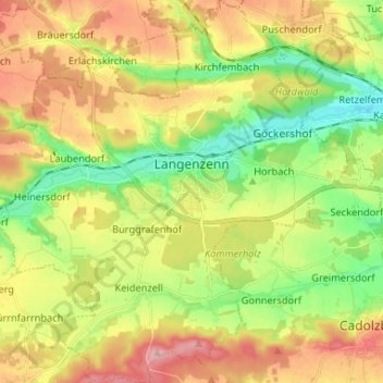
Name: Langenzenn topographic map, elevation, terrain.
Location: Langenzenn, Landkreis Fürth, Bayern, 90579, Deutschland (49.44630 10.71788 49.53141 10.84726)
Average elevation: 354 m
Minimum elevation: 295 m
Maximum elevation: 424 m
Make a donation
Gear up for your next adventure:
As an Amazon Associate, this site earns from qualifying purchases at no extra cost to you.
Other topographic maps
Click on a map to view its topography, its elevation and its terrain.
Make a donation
Gear up for your next adventure:
As an Amazon Associate, this site earns from qualifying purchases at no extra cost to you.
Make a donation
Gear up for your next adventure:
As an Amazon Associate, this site earns from qualifying purchases at no extra cost to you.
Rehdorf
Deutschland > Bayern > Landkreis Fürth > Oberasbach
Durch das Dorf fließt der Kreuzbach (im Unterlauf Asbach genannt), ein linker Zufluss der Rednitz. Der Ort ist von Acker- und Grünland mit vereinzeltem Baumbestand umgeben. 1 km südlich befindet sich die Wolfshöhe (363 m ü. NHN). Eine Gemeindeverbindungsstraße führt nach Oberasbach (1 km nordöstlich)…
Average elevation: 339 m
Weiherhof
Deutschland > Bayern > Landkreis Fürth > Zirndorf
Das Dorf liegt am Banderbach, einem linken Zufluss der Bibert, am Cadolzburger Höhenzug. Im Westen grenzt der Zirndorfer Stadtwald an, im Norden und Osten der Fürther Stadtwald. Gemeindeverbindungsstraßen führen nach Oberfürberg (1 km nördlich), nach Zirndorf (2,8 km südöstlich), zur Kreisstraße FÜ…
Average elevation: 339 m
Make a donation
Gear up for your next adventure:
As an Amazon Associate, this site earns from qualifying purchases at no extra cost to you.
Hardhof
Deutschland > Bayern > Landkreis Fürth > Langenzenn > Kirchfembach > Hardhof
Average elevation: 349 m
Make a donation
Gear up for your next adventure:
As an Amazon Associate, this site earns from qualifying purchases at no extra cost to you.