
Make a donation
Gear up for your next adventure:
As an Amazon Associate, this site earns from qualifying purchases at no extra cost to you.
Brittoli topographic map
Click on the map to display elevation.
Make a donation
Gear up for your next adventure:
As an Amazon Associate, this site earns from qualifying purchases at no extra cost to you.
About this map
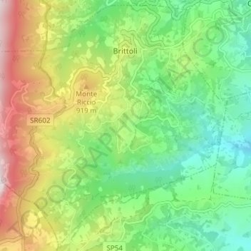
Name: Brittoli topographic map, elevation, terrain.
Location: Brittoli, Pescara, Abruzzo, Italy (42.28205 13.82539 42.32562 13.88668)
Average elevation: 674 m
Minimum elevation: 316 m
Maximum elevation: 1,289 m
Make a donation
Gear up for your next adventure:
As an Amazon Associate, this site earns from qualifying purchases at no extra cost to you.
Other topographic maps
Click on a map to view its topography, its elevation and its terrain.
Make a donation
Gear up for your next adventure:
As an Amazon Associate, this site earns from qualifying purchases at no extra cost to you.
Città Sant'Angelo
Italy > Abruzzo > Pescara > Città Sant'Angelo > Città Sant'Angelo
Average elevation: 123 m
Make a donation
Gear up for your next adventure:
As an Amazon Associate, this site earns from qualifying purchases at no extra cost to you.