Geolocate

Laloux topographic map

Interactive map

Click on the map to display elevation.

About this map

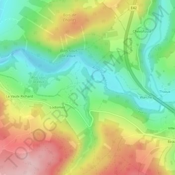
Name: Laloux topographic map, elevation, terrain.

Location: Laloux, Stavelot, Verviers, Liège, Wallonie, 4970, Belgique (50.37831 5.96382 50.39831 5.98382)

Average elevation: 380 m

Minimum elevation: 280 m

Maximum elevation: 517 m

Other topographic maps

Click on a map to view its topography, its elevation and its terrain.

Le Hockai

Belgique > Wallonie > Stavelot

Le Hockai, Stavelot, Verviers, Liège, Wallonie, 4970, Belgique

Average elevation: 464 m

Rivage

Belgique > Wallonie > Stavelot > Rivage

Rivage, Stavelot, Liège, Wallonie, 4970, Belgique

Average elevation: 397 m

Aiwez Faz

Belgique > Wallonie > Stavelot

Aiwez Faz, Chemin du Hécheray, Stavelot, Liège, Wallonie, 4970, Belgique

Average elevation: 451 m

Le Hockai

Belgique > Wallonie > Stavelot

Le Hockai, Stavelot, Verviers, Liège, Wallonie, 4970, Belgique

Average elevation: 478 m