Geolocate

Le Hockai topographic map

Interactive map

Click on the map to display elevation.

About this map

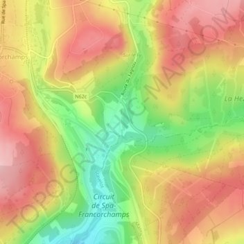
Name: Le Hockai topographic map, elevation, terrain.

Location: Le Hockai, Stavelot, Verviers, Liège, Wallonie, 4970, Belgique (50.44439 5.97309 50.44740 5.97370)

Average elevation: 464 m

Minimum elevation: 365 m

Maximum elevation: 538 m

Other topographic maps

Click on a map to view its topography, its elevation and its terrain.

Rivage

Belgique > Wallonie > Stavelot > Rivage

Rivage, Stavelot, Liège, Wallonie, 4970, Belgique

Average elevation: 397 m

Aiwez Faz

Belgique > Wallonie > Stavelot

Aiwez Faz, Chemin du Hécheray, Stavelot, Liège, Wallonie, 4970, Belgique

Average elevation: 451 m

Le Hockai

Belgique > Wallonie > Stavelot

Le Hockai, Stavelot, Verviers, Liège, Wallonie, 4970, Belgique

Average elevation: 478 m

Laloux

Belgique > Wallonie > Stavelot

Laloux, Stavelot, Verviers, Liège, Wallonie, 4970, Belgique

Average elevation: 380 m