
Råbylille topographic map
Interactive map
Click on the map to display elevation.
About this map
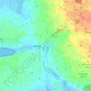
Name: Råbylille topographic map, elevation, terrain.
Location: Råbylille, Vordingborg Kommune, Seeland, Denemarken (54.96880 12.35767 55.00880 12.39767)
Average elevation: 14 m
Minimum elevation: -5 m
Maximum elevation: 44 m
Other topographic maps
Click on a map to view its topography, its elevation and its terrain.
Gedser
Gedser, Guldborgsund Kommune, Seeland, 4874, Denemarken
Average elevation: 0 m
Lammefjorden
Denemarken > Seeland > Gundestrup
Lammefjorden, Gundestrup, Seeland, Denemarken
Average elevation: 10 m
Roskilde
Roskilde, Roskilde Kommune, Seeland, 4000, Denemarken
Average elevation: 25 m