
Kings County topographic map
Interactive map
Click on the map to display elevation.
Kings County
Table Mountain is the highest point in Kings County at an elevation of 3,476 feet (1,059 m). It is located in the Diablo Range in southwestern Kings County on the boundary between Kings and Monterey counties.
About this map
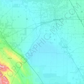
Name: Kings County topographic map, elevation, terrain.
Location: Kings County, California, United States (35.78861 -120.31511 36.48885 -119.47438)
Average elevation: 101 m
Minimum elevation: 53 m
Maximum elevation: 828 m
Other topographic maps
Click on a map to view its topography, its elevation and its terrain.
Crescent City
United States > California > Del Norte County
The topography of the sea floor surrounding Crescent City has the effect of focusing tsunamis. According to researchers at Humboldt State University and the University of Southern California, the city experienced tsunami conditions 31 times between the years 1933 and 2008. Although many of these incidents were…
Average elevation: 31 m
Oakhurst
United States > California > Madera County > Oakhurst
Oakhurst is located on the Fresno River 3 miles (5 km) south-southwest of Yosemite Forks, at an elevation of 2,274 feet (693 m). Its coordinates are 37°19′41″N 119°38′58″W / 37.32806°N 119.64944°W / 37.32806; -119.64944. It is located at the junction of state highways 41 and 49, at the…
Average elevation: 837 m
San Diego
United States > California > San Diego County > San Diego
The climate in San Diego, like most of Southern California, often varies significantly over short geographical distances, resulting in microclimates. In San Diego, this is mostly because of the city's topography (the Bay, and the numerous hills, mountains, and canyons). Frequently, particularly during the "May…
Average elevation: 57 m
San Francisco Bay Area
United States > California > San Francisco
The San Francisco Bay Area is characterized by a diverse and dynamic topography shaped by geological processes over millions of years. This region features a combination of coastal plains, steep hills, and rugged mountains, all influenced by the tectonic activity associated with the nearby San Andreas Fault…
Average elevation: 113 m
Big Sur
United States > California > Monterey County
The highest peaks of the crest of the coast range are located at an average distance from the coast of three and a half miles [5.6 km]. In this distance they rise to elevations of from three thousand six hundred to five thousand feet [1,100 to 1,500 m] above the sea-level. From San Carpoforo Creek to…
Average elevation: 193 m
Coachella Valley
United States > California > Riverside County > Palm Desert
The area is surrounded on the southwest by the Santa Rosa Mountains, by the San Jacinto Mountains to the west, the Little San Bernardino Mountains to the east and San Gorgonio Mountain to the north. These mountains peak at around 11,000 feet (3,400 m) and tend to average between 5,000 and 7,000 feet (1,500 and…
Average elevation: 72 m
Pacheco Pass
United States > California > Santa Clara County
Pacheco Pass, elevation 1,368 ft (417 m), is a low mountain pass located in the Diablo Range in southeastern Santa Clara County, California. It is the main route through the hills separating the Santa Clara Valley and the Central Valley.
Average elevation: 425 m
Mount Shasta
United States > California > Siskiyou County
Mount Shasta (Shasta: Waka-nunee-Tuki-wuki; Karuk: Úytaahkoo) is a potentially active volcano at the southern end of the Cascade Range in Siskiyou County, California. At an elevation of 14,179 feet (4,321.8 meters), it is the second-highest peak in the Cascades and the fifth-highest in the state. Mount Shasta…
Average elevation: 3,717 m
Echo Valley
United States > California > Mariposa County
Echo Valley is a valley in Yosemite National Park, at an elevation of 7,021 feet (2,140 m). It is located along Echo Creek, about 3 miles (5 km) west of Merced Lake, at 37°44′38″N 119°26′03″W / 37.7438°N 119.4343°W / 37.7438; -119.4343. It is bounded on the south by the Merced River.
Average elevation: 2,333 m
Berkeley Hills
United States > California > Alameda County > Berkeley
The Berkeley Hills are bounded by the major Hayward Fault along their western base, and the minor Wildcat fault on their eastern side. The highest peaks are Grizzly Peak with an elevation of 1,754 feet (535 m) and Round Top, an extinct volcano with an elevation of 1,761 feet (537 m) and William Rust Summit at…
Average elevation: 158 m
El Dorado Hills
United States > California > El Dorado County > Cameron Park
El Dorado Hills (EDH), as defined by the 2010 census-designated place (CDP), is at the western border of El Dorado County, between the City of Folsom and the unincorporated community of Cameron Park. The northern limits of the CDP are Folsom Lake and the South Fork of the American River, where river rafters…
Average elevation: 254 m
Manzanar National Historic Site
United States > California > Inyo County > Independence
The Manzanar facility was located between Lone Pine and Independence. The weather at Manzanar caused suffering for the inmates, few of whom were accustomed to the extremes of the area's climate. While the majority of people were from the Los Angeles area, some were from places with much different climates…
Average elevation: 1,189 m
San Francisco Maritime National Historical Park
United States > California > San Francisco
Average elevation: 11 m
Hungry Valley SVRA
United States > California > Los Angeles County > Gorman
Average elevation: 1,303 m
North Santa Maria
United States > California > Santa Barbara County > Santa Maria
Average elevation: 65 m
Mettler
United States > California > Kern County > Mettler
Mettler is 25 miles (40 km) south of Bakersfield.[1] The locality has an area of 0.2 square miles (0.52 km2) and an elevation of 541 feet (165 m).
Average elevation: 164 m
Fort Irwin
United States > California > San Bernardino County
Fort Irwin National Training Center (Fort Irwin NTC) is a major training area for the United States military in the Mojave Desert in northern San Bernardino County, California. Fort Irwin is at an average elevation of 2,454 feet (748 m). It is located 37 miles (60 km) northeast of Barstow, in the Calico…
Average elevation: 774 m
Point Sur Lighthouse
United States > California > Monterey County > Big Sur Village
Average elevation: 11 m
Whitewater
United States > California > Riverside County
Whitewater (formerly White Water) is a census-designated place in Riverside County, California. It is directly off Interstate 10 halfway between North Palm Springs and Cabazon on the way from Palm Springs to Los Angeles. It is known as the site of the San Gorgonio Pass Wind Farm. The ZIP Code is 92282, and the…
Average elevation: 451 m
Bouverie Wildflower Preserve
United States > California > Sonoma County > Glen Ellen
Average elevation: 135 m
Frazier Park
United States > California > Kern County
Frazier Park is a village and unincorporated community in Kern County, California. It is 5 miles (8 km) west of Lebec, at an elevation of 4,639 feet (1,414 m). It is one of the Mountain Communities of the Tejon Pass. The population was 2,592 in the 2020 census, down from 2,691 in 2010.
Average elevation: 1,533 m
Ramona
United States > California > San Diego County
In January 2006, Ramona Valley was designated the country's 162nd American Viticultural Area (AVA) by the Alcohol and Tobacco Tax and Trade Bureau, which recognized the area for its distinctive microclimate, elevation, and soil attributes.
Average elevation: 469 m