Geolocate

Cascade topographic map

Click on the map to display elevation.

About this map

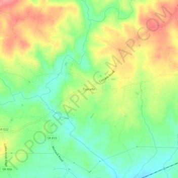
Name: Cascade topographic map, elevation, terrain.

Location: Cascade, Pittsylvania County, Virginia, 24069, United States (36.54458 -79.68975 36.58458 -79.64975)

Average elevation: 194 m

Minimum elevation: 152 m

Maximum elevation: 246 m

Gear up for your next adventure:

🔥Windproof Plasma Lighters - USB rechargeable lighters that work in high-altitude winds
🧼Biodegradable Soap - Eco-friendly outdoor soap
📷Backpack Camera Clips - Quick access to your camera while keeping your hands free for climbing
🔪Camping Knives - Multi-purpose outdoor knives
💡Collapsible Camping Lanterns - Illuminate your base camp or tent for map studying at night

As an Amazon Associate, this site earns from qualifying purchases at no extra cost to you.