
Viseu topographic map
Interactive map
Click on the map to display elevation.
About this map
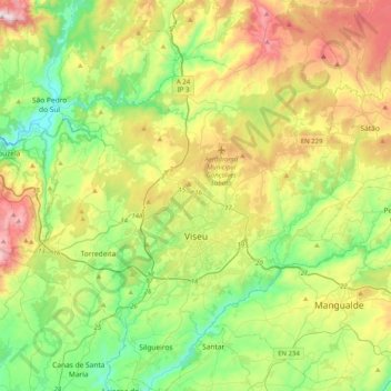
Name: Viseu topographic map, elevation, terrain.
Location: Viseu, Portugal (40.53573 -8.09159 40.84260 -7.75898)
Average elevation: 469 m
Minimum elevation: 146 m
Maximum elevation: 1,067 m
El municipio tiene una superficie irregular con altitudes comprendidas entre los 400 y 700 m sobre el nivel del mar.
Other topographic maps
Click on a map to view its topography, its elevation and its terrain.
São João de Lourosa
São João de Lourosa, Viseu, Portugal
Average elevation: 401 m
Loureiro
Portugal > Viseu > Viseu > Silgueiros
Loureiro, Silgueiros, Viseu, 3460-391, Portugal
Average elevation: 320 m