
Batang Padang River topographic map
Interactive map
Click on the map to display elevation.
About this map
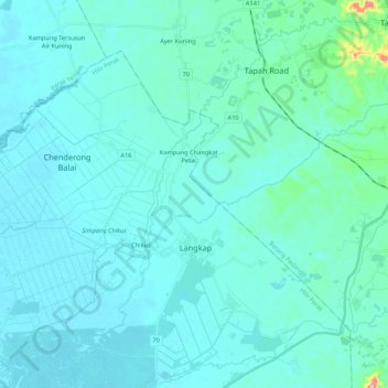
Name: Batang Padang River topographic map, elevation, terrain.
Location: Batang Padang River, Teluk Intan, Perak, 35000, Malaysia (4.00767 101.07652 4.20159 101.29062)
Average elevation: 19 m
Minimum elevation: 1 m
Maximum elevation: 204 m
Other topographic maps
Click on a map to view its topography, its elevation and its terrain.
Sungai Bidor
Malaysia > Perak > Teluk Intan
Sungai Bidor, Bandar Lama, Teluk Intan, Hilir Perak, Perak, Malaysia
Average elevation: 4 m
Sungai Sungkai
Malaysia > Perak > Teluk Intan
Sungai Sungkai, Teluk Intan, Perak, Malaysia
Average elevation: 26 m