
Galston topographic map
Interactive map
Click on the map to display elevation.
About this map
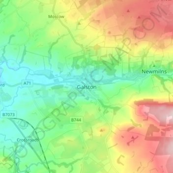
Name: Galston topographic map, elevation, terrain.
Location: Galston, East Ayrshire, Scotland, KA4 8HG, United Kingdom (55.56041 -4.41975 55.64041 -4.33975)
Average elevation: 126 m
Minimum elevation: 30 m
Maximum elevation: 297 m
Other topographic maps
Click on a map to view its topography, its elevation and its terrain.
Kilmarnock
United Kingdom > Scotland > East Ayrshire
Kilmarnock, East Ayrshire, Scotland, KA1 1HZ, United Kingdom
Average elevation: 56 m
Cumnock
United Kingdom > Scotland > East Ayrshire
Cumnock, East Ayrshire, Scotland, KA18 1AY, United Kingdom
Average elevation: 187 m
Dalmellington
United Kingdom > Scotland > East Ayrshire
Dalmellington, East Ayrshire, Scotland, KA6 7QU, United Kingdom
Average elevation: 285 m
Dunlop
United Kingdom > Scotland > East Ayrshire
Dunlop, East Ayrshire, Scotland, KA3 4AF, United Kingdom
Average elevation: 132 m