
Plage La Française topographic map
Interactive map
Click on the map to display elevation.
About this map
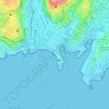
Name: Plage La Française topographic map, elevation, terrain.
Location: Plage La Française, Fort-de-France, Martinique, France (14.60061 -61.06788 14.60162 -61.06707)
Average elevation: 18 m
Minimum elevation: -4 m
Maximum elevation: 136 m
Other topographic maps
Click on a map to view its topography, its elevation and its terrain.
Baie des Tourelles
France > Martinique > Fort-de-France
Baie des Tourelles, Fort-de-France, Martinique, 97200, France
Average elevation: 11 m