
SBY topographic map
Interactive map
Click on the map to display elevation.
About this map
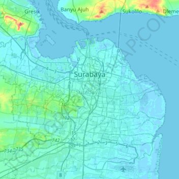
Name: SBY topographic map, elevation, terrain.
Location: SBY, Jatim, Indonesia (-7.35144 112.59157 -7.18423 112.84680)
Average elevation: 8 m
Minimum elevation: -4 m
Maximum elevation: 107 m
Other topographic maps
Click on a map to view its topography, its elevation and its terrain.
Kawah Ijen
Kawah Ijen, Blue Fire trek, Kalipuro, Jatim, Indonesia
Average elevation: 2,175 m
Gunung Penanjakan
Gunung Penanjakan, Pasuruan, Jatim, Indonesia
Average elevation: 2,427 m
Ketapang
Indonesia > Jatim > Probolinggo
Ketapang, Probolinggo, Jatim, Indonesia
Average elevation: 0 m