
Chiang Mai topographic map
Interactive map
Click on the map to display elevation.
About this map
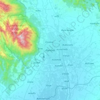
Name: Chiang Mai topographic map, elevation, terrain.
Average elevation: 424 m
Minimum elevation: 291 m
Maximum elevation: 1,670 m
Chiang Mai has a tropical savanna climate (Köppen Aw), tempered by the low latitude and moderate elevation, with warm to hot weather year-round, though nighttime conditions during the dry season can be cool and much lower than daytime highs. The maximum temperature ever recorded was 42.5 °C (108.5 °F) in May 2016. Cold and hot weather effects occur immediately but cold effects last longer than hot effects and contribute to higher cold related mortality risk among old people aged more than 85 years.
Other topographic maps
Click on a map to view its topography, its elevation and its terrain.
Mae Raem
Thailand > Chiang Mai Province
Mae Raem, Chiang Mai Province, 50180, Thailand
Average elevation: 573 m
San Pa Tong
Thailand > Chiang Mai Province
San Pa Tong, Yu Wa, Chiang Mai Province, 50120, Thailand
Average elevation: 300 m
Chiang Mai Province
Thailand > Chiang Mai Province
Chiang Mai Province, Thailand
Average elevation: 649 m
Mae Rim
Thailand > Chiang Mai Province
Mae Rim, Rim Nuea, Chiang Mai Province, 50180, Thailand
Average elevation: 340 m
Nong Pa Khrang
Thailand > Chiang Mai Province
Nong Pa Khrang, Ton Pao, Saraphi District, Chiang Mai Province, 55520, Thailand
Average elevation: 307 m
Ban Tong Luang
Thailand > Chiang Mai Province > Ban Tong Luang
Ban Tong Luang, Chiang Mai Province, 50180, Thailand
Average elevation: 671 m
Doi Pha Hom Pok National Park
Thailand > Chiang Mai Province > Ban Huey Mak Liam
Doi Pha Hom Pok National Park, ชม.3015, Ban Huey Mak Liam, Chiang Mai Province, Thailand
Average elevation: 847 m