
Make a donation
Gear up for your next adventure:
As an Amazon Associate, this site earns from qualifying purchases at no extra cost to you.
Styria topographic map
Click on the map to display elevation.
Make a donation
Gear up for your next adventure:
As an Amazon Associate, this site earns from qualifying purchases at no extra cost to you.
About this map
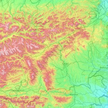
Name: Styria topographic map, elevation, terrain.
Location: Styria, Austria (46.61199 13.56335 47.82789 16.17178)
Average elevation: 767 m
Minimum elevation: 158 m
Maximum elevation: 2,579 m
Make a donation
Gear up for your next adventure:
As an Amazon Associate, this site earns from qualifying purchases at no extra cost to you.
Other topographic maps
Click on a map to view its topography, its elevation and its terrain.
Kleinwolfstein
Austria > Lower Austria > Bezirk Amstetten > Neustadtl an der Donau
Average elevation: 364 m
Make a donation
Gear up for your next adventure:
As an Amazon Associate, this site earns from qualifying purchases at no extra cost to you.
Make a donation
Gear up for your next adventure:
As an Amazon Associate, this site earns from qualifying purchases at no extra cost to you.
Pasterze
Austria > Carinthia > Bezirk Spittal an der Drau > Heiligenblut am Großglockner
Average elevation: 2,599 m
Make a donation
Gear up for your next adventure:
As an Amazon Associate, this site earns from qualifying purchases at no extra cost to you.
Schenkenbrunn
Austria > Lower Austria > Bezirk Krems > Bergern im Dunkelsteinerwald
Average elevation: 511 m
Make a donation
Gear up for your next adventure:
As an Amazon Associate, this site earns from qualifying purchases at no extra cost to you.
Poysdorf
Austria > Lower Austria > Bezirk Mistelbach > Gemeinde Poysdorf > Poysdorf
Average elevation: 246 m
Salmannsdorf
Austria > Burgenland > Bezirk Oberpullendorf > Gemeinde Pilgersdorf > Salmannsdorf
Average elevation: 473 m
Bach
Austria > Carinthia > Bezirk Spittal an der Drau > Bad Kleinkirchheim > Bach
Average elevation: 1,348 m
Make a donation
Gear up for your next adventure:
As an Amazon Associate, this site earns from qualifying purchases at no extra cost to you.