Geolocate

Valberg topographic map

Click on the map to display elevation.

About this map

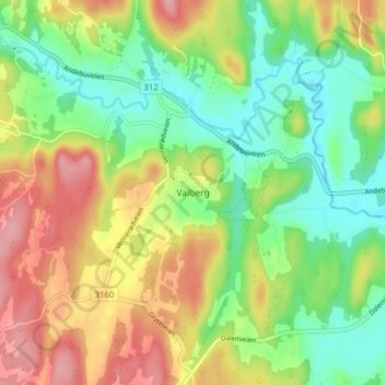
Name: Valberg topographic map, elevation, terrain.

Location: Valberg, Sandefjord, Vestfold og Telemark, 3171, Norway (59.26024 10.23729 59.30024 10.27729)

Average elevation: 57 m

Minimum elevation: 11 m

Maximum elevation: 117 m

Other topographic maps

Click on a map to view its topography, its elevation and its terrain.

Holmestrand

Norway > Vestfold og Telemark

Average elevation: 187 m

Seljord

Norway > Vestfold og Telemark

Average elevation: 720 m

Larvik

Norway > Vestfold og Telemark

Average elevation: 86 m

Porsgrunn

Norway > Vestfold og Telemark

Average elevation: 87 m

Gear up for your next adventure:

🗺️Topographic Maps - Detailed maps for hiking and navigation
🔦Powerful LED Headlamps - Hands-free lighting for night navigation and setting up camp after dark
👖Convertible Hiking Trousers - Zip-off legs to adapt to changing temperatures throughout the day
🕯️Emergency Whistles - Safety whistles for hiking
🔌Fast Charging Adapters - Quickly top up all your gear before heading back into the field

As an Amazon Associate, this site earns from qualifying purchases at no extra cost to you.