
Piura topographic map
Interactive map
Click on the map to display elevation.
About this map
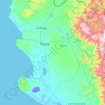
Name: Piura topographic map, elevation, terrain.
Location: Piura, Pérou (-6.36055 -81.47896 -4.36055 -79.47896)
Average elevation: 389 m
Minimum elevation: -25 m
Maximum elevation: 3,830 m
Other topographic maps
Click on a map to view its topography, its elevation and its terrain.
Montelima
Pérou > Piura > Ignacio Escudero
Montelima, Ignacio Escudero, Sullana, Piura, Pérou
Average elevation: 30 m
Madre de Dios
Madre de Dios, Lancones, Sullana, Piura, Pérou
Average elevation: 132 m