
Nares Land topographic map
Interactive map
Click on the map to display elevation.
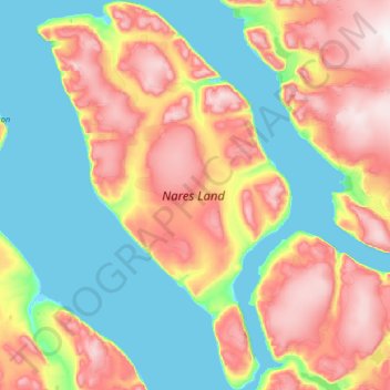
Nares Land
The island lies between the Victoria Fjord and the Nordenskjöld Fjord separated from the Freuchen Land Peninsula of the mainland by a narrow sound. Stephenson Island and John Murray Island lie off its northern end. Nares Land is fairly large, with an area of 1,466 square kilometres (566 square miles) and a shoreline of 192.4 kilometres (119.6 miles). It is 75 kilometres (47 miles) long and up to 30 kilometres (19 miles) wide in its widest place. It has an average elevation of 161 metres (528 feet) and its highest point is 1,067 metres (3,501 feet).
About this map
Name: Nares Land topographic map, elevation, terrain.
Location: Nares Land, Greenland (81.91374 -48.46393 82.60944 -45.07983)
Average elevation: 328 m
Minimum elevation: -1 m
Maximum elevation: 1,210 m
Other topographic maps
Click on a map to view its topography, its elevation and its terrain.