
Balgownie topographic map
Interactive map
Click on the map to display elevation.
About this map
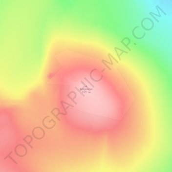
Name: Balgownie topographic map, elevation, terrain.
Location: Balgownie, Greenland (76.11201 -26.54783 76.11211 -26.54773)
Average elevation: 1,846 m
Minimum elevation: 1,759 m
Maximum elevation: 1,909 m
Other topographic maps
Click on a map to view its topography, its elevation and its terrain.
Nares Land
The island lies between the Victoria Fjord and the Nordenskjöld Fjord separated from the Freuchen Land Peninsula of the mainland by a narrow sound. Stephenson Island and John Murray Island lie off its northern end. Nares Land is fairly large, with an area of 1,466 square kilometres (566 square miles) and a…
Average elevation: 328 m