Geolocate

Huruma topographic map

Click on the map to display elevation.

About this map

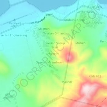
Name: Huruma topographic map, elevation, terrain.

Location: Huruma, Naivasha, Nakuru, Kenya (-0.85349 36.28478 -0.81349 36.32478)

Average elevation: 2,000 m

Minimum elevation: 1,880 m

Maximum elevation: 2,262 m

Other topographic maps

Click on a map to view its topography, its elevation and its terrain.

Kinungi

Kenya > Nakuru > Naivasha

Average elevation: 2,419 m

Hell's Gate National Park

Kenya > Nakuru > Naivasha > Olkaria ward

Average elevation: 1,987 m

Naivasha East ward

Kenya > Nakuru > Naivasha

Average elevation: 2,289 m

Naivasha

Kenya > Nakuru > Naivasha

Average elevation: 1,944 m

Naivasha

Kenya > Nakuru > Naivasha

Average elevation: 1,944 m

Gear up for your next adventure:

🥤Hydration Packs - Hydration systems for hiking
👄SPF Lip Balm - Prevent sun and wind-burnt lips on mountain ridges
🌧️Rain Jackets - Waterproof jackets for hiking
🖼️Scratch-off Australia Map - Track the regions and peaks you have explored geographically
🎒Hiking Backpacks - Backpacks designed for hiking and trekking

As an Amazon Associate, this site earns from qualifying purchases at no extra cost to you.