
Phong Nha-Kẻ Bàng National Park topographic map
Interactive map
Click on the map to display elevation.
About this map
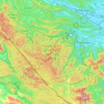
Name: Phong Nha-Kẻ Bàng National Park topographic map, elevation, terrain.
Average elevation: 424 m
Minimum elevation: -2 m
Maximum elevation: 1,597 m
In the late 19th century, Léopold Michel Cadière, a French Roman Catholic priest, conducted an expedition to explore Phong Nha cave, where he discovered Champa scripts. He proclaimed Phong Nha cave "The number one cave of Indochina". In July 1924, an English expeditionist (surnamed Barton) stated that Phong Nha cave is second to none of famous caves of Padirac (France), Cuevas del Drach (Spain). In 1935, a local inhabitant accidentally discovered a beautiful cave 1 km from the mouth of Phong Nha cave, at an elevation of 200 meters. It was called Tien Son cave (lit.: Fairy-tale cave), or Dry cave because its inside landscape is similar to fairy-tales and it has no underground river.
Other topographic maps
Click on a map to view its topography, its elevation and its terrain.
Gia Ninh
Vietnam > Quang Binh province > Quảng Ninh District
Gia Ninh, Quảng Ninh District, Quảng Bình Province, Vietnam
Average elevation: 9 m
Sơn Lý
Vietnam > Quang Binh province > Bố Trạch District
Sơn Lý, Bố Trạch District, Quang Binh province, Vietnam
Average elevation: 34 m
Son Doong Cave
Vietnam > Quang Binh province > Bố Trạch
Son Doong Cave, West Ho Chi Minh Highway, Bố Trạch, Quang Binh province, Vietnam
Average elevation: 487 m
Lệ Thủy District
Lệ Thủy District, Quang Binh province, Vietnam
Average elevation: 171 m
Quảng Ninh District
Quảng Ninh District, Quang Binh province, Vietnam
Average elevation: 308 m
Kiến Giang
Vietnam > Quang Binh province > Lệ Thủy District > Kiến Giang
Kiến Giang, Lệ Thủy District, Quang Binh province, Vietnam
Average elevation: 3 m
Bố Trạch District
Bố Trạch District, Quảng Bình Province, Vietnam
Average elevation: 356 m
Phong Nha Town
Vietnam > Quang Binh province > Bố Trạch District
Phong Nha Town, Bố Trạch District, Quảng Bình Province, Vietnam
Average elevation: 66 m