
Anaga topographic map
Interactive map
Click on the map to display elevation.
About this map
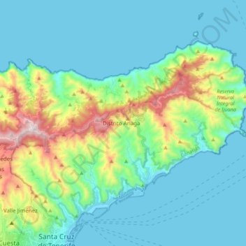
Name: Anaga topographic map, elevation, terrain.
Location: Anaga, Santa Cruz de Tenerife, Canarias, España (28.47414 -16.28598 28.60540 -16.11938)
Average elevation: 210 m
Minimum elevation: -1 m
Maximum elevation: 1,010 m
Other topographic maps
Click on a map to view its topography, its elevation and its terrain.
Castillo de San Juan Bautista
España > Santa Cruz de Tenerife
Castillo de San Juan Bautista, Avenida de la Constitución, Los Llanos, Distrito Salud-La Salle, Salud-La Salle, Santa Cruz de Tenerife, Canarias, 38005, España
Average elevation: 19 m