
Norwood topographic map
Interactive map
Click on the map to display elevation.
About this map
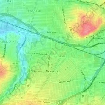
Name: Norwood topographic map, elevation, terrain.
Location: Norwood, Hamilton County, Ohio, 45212, United States (39.14482 -84.47367 39.17819 -84.43460)
Average elevation: 196 m
Minimum elevation: 161 m
Maximum elevation: 246 m
The earliest humans in the area now known as Norwood are believed to have been Pre-Columbian era people of the Adena culture. Norwood Mound, a prehistoric earthwork mound built by the Adena, is located in Norwood and listed on the National Register of Historic Places. The Adena constructed the mound at the location of Norwood's present-day Water Tower Park, which is the highest land elevation in the city. Archaeologists believe the mound was built at this site due to the high elevation and was used by the Adena for religious ceremonies and smoke signaling.
Other topographic maps
Click on a map to view its topography, its elevation and its terrain.
Cincinnati
United States > Ohio > Hamilton County
Cincinnati, Hamilton County, Ohio, United States
Average elevation: 222 m
Symmes Township Park
United States > Ohio > Hamilton County > Loveland
Symmes Township Park, Loveland, Symmes Township, Hamilton County, Ohio, United States
Average elevation: 226 m
Amberley Village
United States > Ohio > Hamilton County
Amberley Village, Hamilton County, Ohio, United States
Average elevation: 226 m
Forest Park
United States > Ohio > Hamilton County
Forest Park, Hamilton County, Ohio, United States
Average elevation: 234 m
Montgomery Heights
United States > Ohio > Hamilton County > Montgomery > Montgomery Heights
Montgomery Heights, Montgomery, Hamilton County, Ohio, 45242-5324, United States
Average elevation: 241 m
Northgate
United States > Ohio > Hamilton County > Northgate
Northgate, Colerain Township, Hamilton County, Ohio, United States
Average elevation: 264 m