
Cincinnati topographic map
Interactive map
Click on the map to display elevation.
About this map
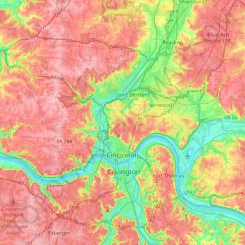
Name: Cincinnati topographic map, elevation, terrain.
Location: Cincinnati, Hamilton County, Ohio, United States (39.05206 -84.71239 39.22104 -84.36958)
Average elevation: 222 m
Minimum elevation: 139 m
Maximum elevation: 293 m
Cincinnati has several standard modes of transportation including sidewalks, roads, public transit, bicycle paths and airports. The city's hills preclude the regular street grid common to many cities built up in the 19th century, and outside of the downtown basin, regular street grids are rare except for in patches of flat land where they are small and oriented according to topography.
Other topographic maps
Click on a map to view its topography, its elevation and its terrain.
Symmes Township Park
United States > Ohio > Hamilton County > Loveland
Symmes Township Park, Loveland, Symmes Township, Hamilton County, Ohio, United States
Average elevation: 226 m
Amberley Village
United States > Ohio > Hamilton County
Amberley Village, Hamilton County, Ohio, United States
Average elevation: 226 m
Forest Park
United States > Ohio > Hamilton County
Forest Park, Hamilton County, Ohio, United States
Average elevation: 234 m
Montgomery Heights
United States > Ohio > Hamilton County > Montgomery > Montgomery Heights
Montgomery Heights, Montgomery, Hamilton County, Ohio, 45242-5324, United States
Average elevation: 241 m
Northgate
United States > Ohio > Hamilton County > Northgate
Northgate, Colerain Township, Hamilton County, Ohio, United States
Average elevation: 264 m
Norwood
United States > Ohio > Hamilton County
Norwood, Hamilton County, Ohio, 45212, United States
Average elevation: 196 m