
Shawville topographic map
Interactive map
Click on the map to display elevation.
About this map
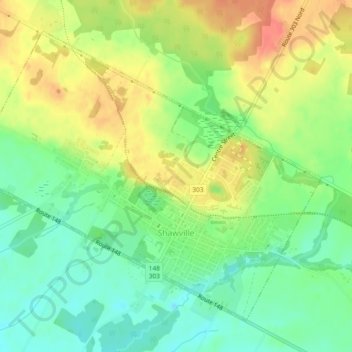
Name: Shawville topographic map, elevation, terrain.
Location: Shawville, Pontiac, Outaouais, Quebec, J0X 2Y0, Canada (45.59538 -76.51885 45.62229 -76.47223)
Average elevation: 171 m
Minimum elevation: 146 m
Maximum elevation: 199 m
Other topographic maps
Click on a map to view its topography, its elevation and its terrain.
Otter Lake
Otter Lake, Pontiac, Outaouais, Quebec, J0X 2P0, Canada
Average elevation: 262 m
Lac Emro
Canada > Quebec > Pontiac > Lac-Nilgaut
Lac Emro, Lac-Nilgaut, Pontiac, Outaouais, Quebec, Canada
Average elevation: 311 m
Lac Forant
Canada > Quebec > Pontiac > Lac-Nilgaut
Lac Forant, Lac-Nilgaut, Pontiac, Outaouais, Quebec, Canada
Average elevation: 285 m