
Thank you for supporting this site ❤️
Make a donation
Make a donation
Gear up for your next adventure:
As an Amazon Associate, this site earns from qualifying purchases at no extra cost to you.
Badgastein topographic map
Click on the map to display elevation.
Thank you for supporting this site ❤️
Make a donation
Make a donation
Gear up for your next adventure:
As an Amazon Associate, this site earns from qualifying purchases at no extra cost to you.
About this map
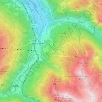
Name: Badgastein topographic map, elevation, terrain.
Location: Badgastein, Salzburg, 5640, Austria (47.08161 13.11275 47.13890 13.18101)
Average elevation: 1,531 m
Minimum elevation: 845 m
Maximum elevation: 2,468 m
Thank you for supporting this site ❤️
Make a donation
Make a donation
Gear up for your next adventure:
📣High-Decibel Survival Whistles - Signaling tool for rescue that carries much further than a human voice
As an Amazon Associate, this site earns from qualifying purchases at no extra cost to you.
Other topographic maps
Click on a map to view its topography, its elevation and its terrain.