
Valdelinares topographic map
Interactive map
Click on the map to display elevation.
About this map
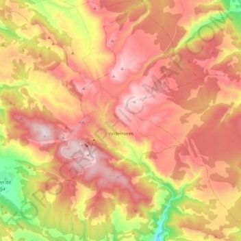
Name: Valdelinares topographic map, elevation, terrain.
Location: Valdelinares, Gúdar-Javalambre, Teruel, Aragon, Espagne (40.32767 -0.65057 40.47014 -0.54458)
Average elevation: 1,723 m
Minimum elevation: 1,299 m
Maximum elevation: 2,017 m
Valdelinares est situé à 1 692 m d'altitude en pleine Sierra de Gúdar, dans le Système Ibérique, c'est la commune (mais pas la municipalité) la plus haute d'Espagne.
Other topographic maps
Click on a map to view its topography, its elevation and its terrain.
Tarrascón
Espagne > Aragon > Valdelinares
Tarrascón, Valdelinares, Gúdar-Javalambre, Teruel, Aragon, Espagne
Average elevation: 1,785 m