
Make a donation
Gear up for your next adventure:
As an Amazon Associate, this site earns from qualifying purchases at no extra cost to you.
Manawatū-Whanganui topographic map
Click on the map to display elevation.
Make a donation
Gear up for your next adventure:
As an Amazon Associate, this site earns from qualifying purchases at no extra cost to you.
Manawatū-Whanganui
The area includes a variety of landscape formations. Districts close to the Volcanic Plateau are higher and more rugged, often subject to harsh temperatures in winter. The Manawatū District has a much gentler topography, consisting mainly of the flat, tree-studded Manawatū Plains that run between the ranges and the sea. The land was under the sea till about 500,000 years ago and still has a very thick layer of marine sediment, which is about five or six million years old. A block faulting system underneath the thick sediment has raised a series of domes and gentle depressions. These structures can provide natural storage areas for oil and some of the Manawatu domes have been drilled. The domes have shaped the course of the Manawatū River, giving it a meandering path which, uniquely among New Zealand rivers, begins close to the east coast and exits on the west coast. The Manawatū River begins just inside the Hawke's Bay Region, then flows through a deep gorge to the Manawatu Plains before exiting in the Tasman Sea. The river is also unique in New Zealand (and rare worldwide) in that this gorge (the Manawatū Gorge) is a water gap through recently uplifted rock, causing the river to flow from relatively low-lying land along an eroded course through higher terrain. The Whanganui District is more rugged, with canyon-like valleys and gorges carved out of the soft rock by rivers and ocean waves.
Make a donation
Gear up for your next adventure:
As an Amazon Associate, this site earns from qualifying purchases at no extra cost to you.
About this map
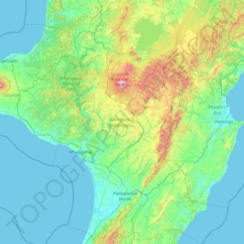
Name: Manawatū-Whanganui topographic map, elevation, terrain.
Location: Manawatū-Whanganui, New Zealand (-40.81095 174.67517 -38.47033 176.89427)
Average elevation: 306 m
Minimum elevation: 0 m
Maximum elevation: 2,717 m
Make a donation
Gear up for your next adventure:
As an Amazon Associate, this site earns from qualifying purchases at no extra cost to you.
Other topographic maps
Click on a map to view its topography, its elevation and its terrain.
Auckland
Auckland’s topography is uniquely shaped by its position on a narrow, undulating isthmus between the Waitematā Harbour to the north and the Manukau Harbour to the south, creating a landscape defined by low coastal plains interrupted by abrupt volcanic relief. The city stands atop the Auckland Volcanic…
Average elevation: 32 m
Wellington
New Zealand > Wellington > Wellington City
Averaging 2,055 hours of sunshine per year, the climate of Wellington is temperate marine, (Köppen: Cfb), generally moderate all year round with warm summers and mild winters, and rarely sees temperatures above 23 °C (73 °F) or below 4 °C (39 °F). The hottest recorded temperature in the city is 31.1 °C…
Average elevation: 85 m
Dunedin
New Zealand > Otago > Dunedin City
The climate of Dunedin in general is temperate. The city is recognised as having a large number of microclimates and the weather conditions often vary between suburbs mostly due to the city's topographical layout. Under the Köppen climate classification, Dunedin features an oceanic climate. The city's climate…
Average elevation: 110 m
Queenstown
New Zealand > Otago > Queenstown-Lakes District
The town is at a relatively low altitude for a ski and snowboarding centre, at 310 metres (1,020 ft) above sea level at the lake shore, but is nestled among mountains, most notably the scenic attraction of The Remarkables, to the town's southeast. Below the lake lies the deep Kawarau Gorge, and there are…
Average elevation: 592 m
Make a donation
Gear up for your next adventure:
As an Amazon Associate, this site earns from qualifying purchases at no extra cost to you.
Palmerston North
New Zealand > Manawatu-Whanganui > Palmerston North City
Although the land Palmerston North is situated on is bounded by the lofty Ruahine and Tararua ranges in the east and south respectively, the city has a predominantly flat appearance. The occasional rise in elevation occurs further away from the river and is especially pronounced in the north and northeast, and…
Average elevation: 118 m
Make a donation
Gear up for your next adventure:
As an Amazon Associate, this site earns from qualifying purchases at no extra cost to you.
Mount Arthur
Mount Arthur (Tuao Wharepapa in Māori) is in the Wharepapa / Arthur Range in the north western area of the South Island of New Zealand. Mount Arthur, named after Captain Arthur Wakefield, lies within Kahurangi National Park and has a peak elevation of 1,795 metres (5,889 ft).
Average elevation: 1,447 m
Make a donation
Gear up for your next adventure:
As an Amazon Associate, this site earns from qualifying purchases at no extra cost to you.
Make a donation
Gear up for your next adventure:
As an Amazon Associate, this site earns from qualifying purchases at no extra cost to you.
Make a donation
Gear up for your next adventure:
As an Amazon Associate, this site earns from qualifying purchases at no extra cost to you.
Make a donation
Gear up for your next adventure:
As an Amazon Associate, this site earns from qualifying purchases at no extra cost to you.
Lake Quill
New Zealand > Southland > Southland District > Fiordland Community
Average elevation: 1,228 m
Make a donation
Gear up for your next adventure:
As an Amazon Associate, this site earns from qualifying purchases at no extra cost to you.
Make a donation
Gear up for your next adventure:
As an Amazon Associate, this site earns from qualifying purchases at no extra cost to you.
Make a donation
Gear up for your next adventure:
As an Amazon Associate, this site earns from qualifying purchases at no extra cost to you.
Make a donation
Gear up for your next adventure:
As an Amazon Associate, this site earns from qualifying purchases at no extra cost to you.
Make a donation
Gear up for your next adventure:
As an Amazon Associate, this site earns from qualifying purchases at no extra cost to you.
Mararoa River
New Zealand > Southland > Southland District > Fiordland Community
Average elevation: 681 m
Make a donation
Gear up for your next adventure:
As an Amazon Associate, this site earns from qualifying purchases at no extra cost to you.
Make a donation
Gear up for your next adventure:
As an Amazon Associate, this site earns from qualifying purchases at no extra cost to you.
Make a donation
Gear up for your next adventure:
As an Amazon Associate, this site earns from qualifying purchases at no extra cost to you.
Make a donation
Gear up for your next adventure:
As an Amazon Associate, this site earns from qualifying purchases at no extra cost to you.
Make a donation
Gear up for your next adventure:
As an Amazon Associate, this site earns from qualifying purchases at no extra cost to you.
Make a donation
Gear up for your next adventure:
As an Amazon Associate, this site earns from qualifying purchases at no extra cost to you.
Rawene
New Zealand > Northland > Far North District > Kaikohe-Hokianga Community
Average elevation: 8 m
Make a donation
Gear up for your next adventure:
As an Amazon Associate, this site earns from qualifying purchases at no extra cost to you.
Tūātapere
New Zealand > Southland > Southland District > Tuatapere Te Waewae Community
Average elevation: 41 m
Make a donation
Gear up for your next adventure:
As an Amazon Associate, this site earns from qualifying purchases at no extra cost to you.
Make a donation
Gear up for your next adventure:
As an Amazon Associate, this site earns from qualifying purchases at no extra cost to you.
Mount Aspiring
New Zealand > West Coast > Westland District
Mount Aspiring / Tititea is New Zealand's 23rd-highest mountain. The peak's altitude of 3,033 metres (9,951 ft) makes it the country's highest outside the Aoraki / Mount Cook National Park region.
Average elevation: 2,257 m
Mount Ruapehu
New Zealand > Manawatu-Whanganui > Ruapehu District
Ruapehu has a polar tundra climate (Köppen: ET) on the upper slopes, with average temperatures ranging from −4 to 15 °C (25 to 59 °F) in summer and −7 to 7 °C (19 to 45 °F) in winter, depending on elevation and cloudiness. On the lower slopes, Ruapehu has a subpolar oceanic climate (Köppen: Cfc).
Average elevation: 2,474 m
Make a donation
Gear up for your next adventure:
As an Amazon Associate, this site earns from qualifying purchases at no extra cost to you.
Make a donation
Gear up for your next adventure:
As an Amazon Associate, this site earns from qualifying purchases at no extra cost to you.
Mount Tūtoko
New Zealand > Southland > Southland District > Fiordland Community
Average elevation: 1,892 m
Make a donation
Gear up for your next adventure:
As an Amazon Associate, this site earns from qualifying purchases at no extra cost to you.
Make a donation
Gear up for your next adventure:
As an Amazon Associate, this site earns from qualifying purchases at no extra cost to you.
Mount Matthews
New Zealand > Wellington > South Wairarapa District > Featherston Community
Average elevation: 535 m
Mount Anglem / Hananui
New Zealand > Southland > Southland District > Stewart Island / Rakiura Community
Mount Anglem / Hananui is the highest point on New Zealand's Stewart Island / Rakiura. It is located 20 kilometres (12 mi) northwest of Oban, close to the island's north coast, and rises to an elevation of 980 metres (3,215 ft) above sea level. Following the passage of the Ngāi Tahu Claims Settlement Act…
Average elevation: 668 m
Make a donation
Gear up for your next adventure:
As an Amazon Associate, this site earns from qualifying purchases at no extra cost to you.