
Make a donation
Gear up for your next adventure:
As an Amazon Associate, this site earns from qualifying purchases at no extra cost to you.
Manicaland Province topographic map
Click on the map to display elevation.
Make a donation
Gear up for your next adventure:
As an Amazon Associate, this site earns from qualifying purchases at no extra cost to you.
About this map
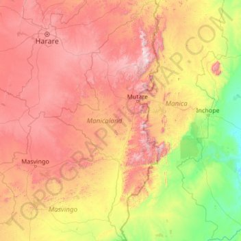
Name: Manicaland Province topographic map, elevation, terrain.
Location: Manicaland Province, Zimbabwe (-21.32857 31.18733 -17.24838 33.06835)
Average elevation: 784 m
Minimum elevation: 4 m
Maximum elevation: 2,489 m
Make a donation
Gear up for your next adventure:
As an Amazon Associate, this site earns from qualifying purchases at no extra cost to you.
Other topographic maps
Click on a map to view its topography, its elevation and its terrain.
Bulawayo
Zimbabwe > Bulawayo Province > Bulawayo
Due to its relatively high altitude, the city has a humid subtropical climate despite lying in the tropics. Under the Köppen climate classification, Bulawayo features a semiarid climate (BSh). The mean annual temperature is 19.16 °C (66.49 °F), similar to Pretoria at a similar altitude but almost 600 km…
Average elevation: 1,348 m
Make a donation
Gear up for your next adventure:
As an Amazon Associate, this site earns from qualifying purchases at no extra cost to you.