Geolocate

Elliston topographic map

Click on the map to display elevation.

About this map

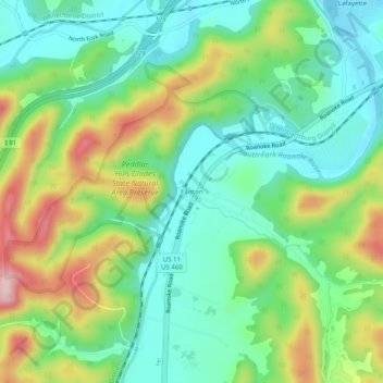
Name: Elliston topographic map, elevation, terrain.

Location: Elliston, Montgomery County, Virginia, 24087, United States (37.19652 -80.25254 37.23652 -80.21254)

Average elevation: 446 m

Minimum elevation: 358 m

Maximum elevation: 616 m

Other topographic maps

Click on a map to view its topography, its elevation and its terrain.

Merrimac

United States > Virginia > Montgomery County > Merrimac

Average elevation: 635 m

Gear up for your next adventure:

🐍Australian Snake Bite Kits - Specific pressure immobilization bandages for Australian venomous snakes
📣High-Decibel Survival Whistles - Signaling tool for rescue that carries much further than a human voice
🗺️Topographic Maps - Detailed maps for hiking and navigation
🔋Solar Power Banks - Solar chargers for outdoors
Altimeter Barometer Watches - Outdoor watches with built-in sensors to track altitude changes and weather shifts

As an Amazon Associate, this site earns from qualifying purchases at no extra cost to you.