
Make a donation
Gear up for your next adventure:
As an Amazon Associate, this site earns from qualifying purchases at no extra cost to you.
Villa Celiera topographic map
Click on the map to display elevation.
Make a donation
Gear up for your next adventure:
As an Amazon Associate, this site earns from qualifying purchases at no extra cost to you.
About this map
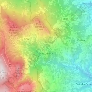
Name: Villa Celiera topographic map, elevation, terrain.
Location: Villa Celiera, Pescara, Abruzzo, Italy (42.36329 13.81019 42.40878 13.88022)
Average elevation: 812 m
Minimum elevation: 325 m
Maximum elevation: 1,572 m
Make a donation
Gear up for your next adventure:
As an Amazon Associate, this site earns from qualifying purchases at no extra cost to you.
Other topographic maps
Click on a map to view its topography, its elevation and its terrain.
Make a donation
Gear up for your next adventure:
As an Amazon Associate, this site earns from qualifying purchases at no extra cost to you.
Città Sant'Angelo
Italy > Abruzzo > Pescara > Città Sant'Angelo > Città Sant'Angelo
Average elevation: 123 m
Make a donation
Gear up for your next adventure:
As an Amazon Associate, this site earns from qualifying purchases at no extra cost to you.