
Santa Cruz topographic map
Click on the map to display elevation.
About this map
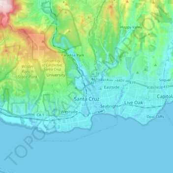
Name: Santa Cruz topographic map, elevation, terrain.
Location: Santa Cruz, Santa Cruz County, California, United States (36.94212 -122.15131 37.02516 -121.98676)
Average elevation: 89 m
Minimum elevation: -1 m
Maximum elevation: 542 m
Other topographic maps
Click on a map to view its topography, its elevation and its terrain.
Mount Hermon
United States > California > Santa Cruz County > Felton > Mount Hermon
Average elevation: 154 m