Western Region topographic map
Click on the map to display elevation.
About this map

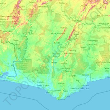
Name: Western Region topographic map, elevation, terrain.
Location: Western Region, Ghana (4.73934 -3.11051 6.15043 -1.40024)
Average elevation: 86 m
Minimum elevation: -2 m
Maximum elevation: 581 m
Other topographic maps
Click on a map to view its topography, its elevation and its terrain.

Atua
Ghana > Western North Region > Aowin Municipal District > Enchi
Atua, Zongo, Enchi, Aowin Municipal District, Western North Region, Ghana
Average elevation: 88 m

Kaneshie
Ghana > Greater Accra Region > Accra Metropolitan District > Accra
Kaneshie, Accra, Accra Metropolitan District, Greater Accra Region, GA-254-4987, Ghana
Average elevation: 24 m


Accra
Ghana > Greater Accra Region > Korle-Klottey Municipal District
Accra, Korle-Klottey Municipal District, Greater Accra Region, Ghana
Average elevation: 31 m

Asankrangwa
Ghana > Western Region > Amenfi West Municipal District
Asankrangwa, Amenfi West Municipal District, Western Region, Ghana
Average elevation: 107 m

Kassena-Nankana West District
Kassena-Nankana West District, Upper East Region, Ghana
Average elevation: 233 m

Accra
Ghana > Greater Accra Region > Korle-Klottey Municipal District
Accra, Korle-Klottey Municipal District, Greater Accra Region, 0302, Ghana
Average elevation: 22 m

Shama
Ghana > Western Region > Shama District
Shama, Shama District, Western Region, Ghana
Average elevation: 8 m