Geolocate

Selborne topographic map

Click on the map to display elevation.

About this map

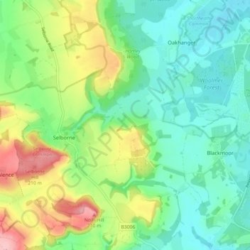
Name: Selborne topographic map, elevation, terrain.

Location: Selborne, East Hampshire, Hampshire, England, United Kingdom (51.07326 -0.96835 51.12757 -0.87892)

Average elevation: 119 m

Minimum elevation: 71 m

Maximum elevation: 221 m

Other topographic maps

Click on a map to view its topography, its elevation and its terrain.

Heath Hill

United Kingdom > England > Hampshire > East Hampshire

Average elevation: 79 m

Gear up for your next adventure:

🧥Thermal Emergency Blankets - Compact Mylar blankets to prevent hypothermia if stranded overnight
🧺Waterproof Dry Sacks - Organize your pack and keep electronics safe from rain and river crossings
🎧Bluetooth Outdoor Earbuds - Listen to navigation cues or podcasts during long solo treks
Altimeter Watches - Watches with altitude tracking
Altimeter Barometer Watches - Outdoor watches with built-in sensors to track altitude changes and weather shifts

As an Amazon Associate, this site earns from qualifying purchases at no extra cost to you.