
Jayapura topographic map
Interactive map
Click on the map to display elevation.
About this map
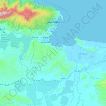
Name: Jayapura topographic map, elevation, terrain.
Location: Jayapura, Papua, Western New Guinea, Indonesia (-2.83925 140.60278 -2.47371 141.00000)
Average elevation: 161 m
Minimum elevation: 0 m
Maximum elevation: 1,955 m
The topography of Jayapura varies from valleys to hills, plateaus, and mountains up to 700 metres (2,300 ft) above sea level. Jayapura overlooks the Yos Sudarso Bay. Jayapura is about 94,000 hectares (230,000 acres) in area, and is divided into five districts. Around 30% of the area is inhabited, with the remainder consisting of a rough terrain, swamps, and protected forest.
Other topographic maps
Click on a map to view its topography, its elevation and its terrain.
Pulau Yapen
Indonesia > Papua > Yapen Islands Regency
Pulau Yapen, Yapen Islands Regency, Papua, 98211, Indonesia
Average elevation: 39 m
Itlay Hisage
Indonesia > Papua > Jayawijaya
Itlay Hisage, Jayawijaya, Papua, Indonesia
Average elevation: 2,943 m
Maoke Mountains
Maoke Mountains, Trikora District, Jayawijaya, Papua, Indonesia
Average elevation: 2,858 m
Undundi-Wandandi
Undundi-Wandandi, Paniai, Papua, Indonesia
Average elevation: 3,185 m
Sungai Mamberamo
Sungai Mamberamo, Mamberamo Raya, Papua, Indonesia
Average elevation: 3 m