
Albacete topographic map
Interactive map
Click on the map to display elevation.
About this map
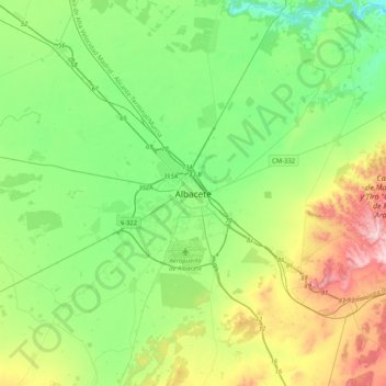
Name: Albacete topographic map, elevation, terrain.
Location: Albacete, Castilla-La Mancha, 02001, España (38.83510 -2.01596 39.15510 -1.69596)
Average elevation: 717 m
Minimum elevation: 596 m
Maximum elevation: 1,001 m
Other topographic maps
Click on a map to view its topography, its elevation and its terrain.
humedales
España > Castilla-La Mancha > Albacete
humedales, Avenida de la Mancha, Urbanización La Pérgola, Universidad, Albacete, Castilla-La Mancha, 02006, España
Average elevation: 690 m