Geolocate

Braintree topographic map

Interactive map

Click on the map to display elevation.

About this map

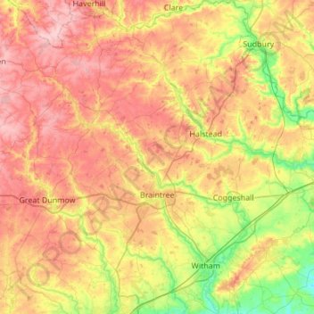
Name: Braintree topographic map, elevation, terrain.

Location: Braintree, Essex, England, United Kingdom (51.75041 0.37961 52.08703 0.78225)

Average elevation: 66 m

Minimum elevation: 3 m

Maximum elevation: 129 m

Other topographic maps

Click on a map to view its topography, its elevation and its terrain.

Chipping Ongar

United Kingdom > England > Essex > Epping Forest

Average elevation: 68 m

Walton-on-the-Naze

United Kingdom > England > Essex > Tendring

Average elevation: 3 m

Swan Street

United Kingdom > England > Essex > Colchester > Chappel

Average elevation: 48 m

Clacton-on-Sea

United Kingdom > England > Essex > Tendring

Average elevation: 7 m

Mobile Phone Tower

United Kingdom > England > Essex > Rayleigh

Average elevation: 53 m

Aveley

United Kingdom > England > Essex

Average elevation: 13 m

Great Holland

United Kingdom > England > Essex > Great Holland

Average elevation: 13 m