
Livingston topographic map
Interactive map
Click on the map to display elevation.
About this map
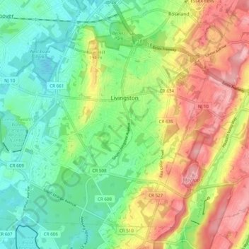
Name: Livingston topographic map, elevation, terrain.
Location: Livingston, Essex County, New Jersey, 07039, United States (40.75760 -74.37752 40.81842 -74.28059)
Average elevation: 104 m
Minimum elevation: 47 m
Maximum elevation: 189 m
Other topographic maps
Click on a map to view its topography, its elevation and its terrain.
Newark
United States > New Jersey > Essex County
Newark, Essex County, New Jersey, United States
Average elevation: 22 m
East Orange
United States > New Jersey > Essex County
East Orange, Essex County, New Jersey, United States
Average elevation: 49 m
Short Hills
United States > New Jersey > Essex County > Millburn > Short Hills
Short Hills, Millburn, Essex County, New Jersey, 07078, United States
Average elevation: 98 m