
Make a donation
Gear up for your next adventure:
As an Amazon Associate, this site earns from qualifying purchases at no extra cost to you.
Astana topographic map
Click on the map to display elevation.
Make a donation
Gear up for your next adventure:
As an Amazon Associate, this site earns from qualifying purchases at no extra cost to you.
Astana
Astana is located in central Kazakhstan on the Ishim River in a very flat, semi-arid steppe region which covers most of the country's territory. It is at 51° 10' north latitude and 71° 26' east longitude. The city encompasses 722.0 square kilometres (278.8 sq mi). The elevation of Astana is 347 metres (1,138 ft) above sea level. Astana is in a spacious steppe landscape, in the transitional area between the north of Kazakhstan and the extremely thinly settled national centre, because of the Ishim River. The older boroughs lie north of the river, whilst the new boroughs are located south of the Ishim.
Make a donation
Gear up for your next adventure:
As an Amazon Associate, this site earns from qualifying purchases at no extra cost to you.
About this map
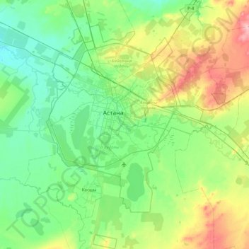
Name: Astana topographic map, elevation, terrain.
Location: Astana, Kazakhstan (50.85761 71.21797 51.35111 71.78519)
Average elevation: 363 m
Minimum elevation: 331 m
Maximum elevation: 462 m
Make a donation
Gear up for your next adventure:
As an Amazon Associate, this site earns from qualifying purchases at no extra cost to you.
Other topographic maps
Click on a map to view its topography, its elevation and its terrain.
Almaty
Kazakhstan > Bostandıq District
Almaty is still the major commercial, financial, and cultural centre of Kazakhstan, as well as its most populous and most cosmopolitan city. The city is located in the mountainous area of southern Kazakhstan near the border with Kyrgyzstan in the foothills of the Trans-Ili Alatau at an elevation of 700–900 m…
Average elevation: 1,261 m
Border Kazakhstan - Russia
Kazakhstan > East Kazakhstan Region > Katonkaragay District
Average elevation: 2,676 m
Make a donation
Gear up for your next adventure:
As an Amazon Associate, this site earns from qualifying purchases at no extra cost to you.
Qorğaljın
Kazakhstan > Akmola Region > Qorğaljın district
The village is located on the Kazakh Uplands. The average altitude in the village is about 330 meters above sea level. The terrain is a continuous plain with small hills and water areas.
Average elevation: 330 m
Make a donation
Gear up for your next adventure:
As an Amazon Associate, this site earns from qualifying purchases at no extra cost to you.