Geolocate

Boreham topographic map

Click on the map to display elevation.

About this map

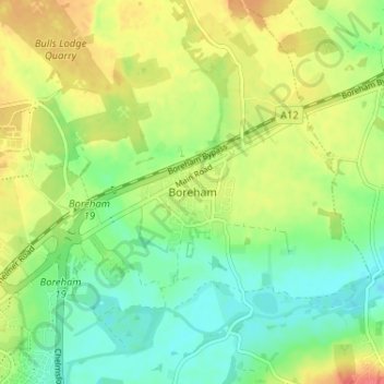
Name: Boreham topographic map, elevation, terrain.

Location: Boreham, Chelmsford, Essex, England, CM3 3BX, United Kingdom (51.74085 0.52248 51.78085 0.56248)

Average elevation: 34 m

Minimum elevation: 10 m

Maximum elevation: 64 m

Other topographic maps

Click on a map to view its topography, its elevation and its terrain.

Broomfield

United Kingdom > England > Essex > Chelmsford

Average elevation: 47 m

Rettendon

United Kingdom > England > Essex > Chelmsford > Rettendon

Average elevation: 26 m

College Wood

United Kingdom > England > Essex > Chelmsford

Average elevation: 42 m

Roxwell

United Kingdom > England > Essex > Chelmsford > Roxwell

Average elevation: 56 m

Springfield

United Kingdom > England > Essex > Chelmsford

Average elevation: 42 m

Sandon

United Kingdom > England > Essex > Chelmsford > Sandon

Average elevation: 41 m

West Hanningfield

United Kingdom > England > Essex > Chelmsford

Average elevation: 56 m

Gear up for your next adventure:

Lightweight Tents - Compact tents for backpacking
🧥Softshell Jackets - Flexible outdoor jackets
🧥Down Jackets - Insulated jackets for cold weather
🔋Rechargeable Batteries - Eco-friendly power for high-drain GPS units and flashlights
🎒Dry Bags - Waterproof bags for outdoor gear

As an Amazon Associate, this site earns from qualifying purchases at no extra cost to you.