
Curuguaty topographic map
Interactive map
Click on the map to display elevation.
About this map
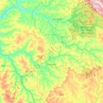
Name: Curuguaty topographic map, elevation, terrain.
Location: Curuguaty, Canindeyú, Región Oriental, Paraguay (-24.72135 -56.17278 -24.01990 -55.31032)
Average elevation: 219 m
Minimum elevation: 103 m
Maximum elevation: 468 m
Le département de Canindeyu une flore très riche et est entourée de régions montagneuses du Mbaracayu, dont l'altitude moyenne est de 400 m au-dessus du niveau de la mer. Il est possible d'apprécier la biodiversité de la Forêt Atlantique.
Other topographic maps
Click on a map to view its topography, its elevation and its terrain.