
Make a donation
Gear up for your next adventure:
As an Amazon Associate, this site earns from qualifying purchases at no extra cost to you.
Mount Katmai topographic map
Click on the map to display elevation.
Make a donation
Gear up for your next adventure:
As an Amazon Associate, this site earns from qualifying purchases at no extra cost to you.
Mount Katmai
Mount Katmai (Russian: Катмай) is a large active stratovolcano (composite volcano) on the Alaska Peninsula in southern Alaska, located within Katmai National Park and Preserve. It is about 6.3 miles (10 km) in diameter with a central lake-filled caldera about two by three miles (3.2 by 4.8 km) in size, formed during the Novarupta eruption of 1912. The caldera rim reaches a maximum elevation of 6,716 feet (2,047 m). In 1975 the surface of the crater lake was at an elevation of about 4,220 feet (1,286 m), and the estimated elevation of the caldera floor is about 3,400 ft (1,040 m). The mountain is located in Kodiak Island Borough, very close to its border with Lake and Peninsula Borough. The volcano has caused ten known fatalities due to gas exposure.
Make a donation
Gear up for your next adventure:
As an Amazon Associate, this site earns from qualifying purchases at no extra cost to you.
About this map
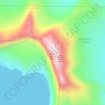
Name: Mount Katmai topographic map, elevation, terrain.
Location: Mount Katmai, Kodiak Island Borough, Alaska, United States (58.27884 -154.95338 58.27894 -154.95328)
Average elevation: 1,515 m
Minimum elevation: 1,274 m
Maximum elevation: 1,968 m
Make a donation
Gear up for your next adventure:
As an Amazon Associate, this site earns from qualifying purchases at no extra cost to you.
Other topographic maps
Click on a map to view its topography, its elevation and its terrain.
Make a donation
Gear up for your next adventure:
As an Amazon Associate, this site earns from qualifying purchases at no extra cost to you.
Make a donation
Gear up for your next adventure:
As an Amazon Associate, this site earns from qualifying purchases at no extra cost to you.