Geolocate

Bayugan topographic map

Click on the map to display elevation.

About this map

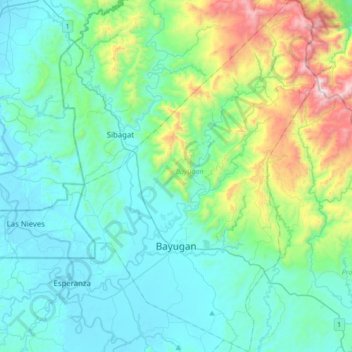
Name: Bayugan topographic map, elevation, terrain.

Location: Bayugan, Agusan del Sur, Caraga, 8502, Philippines (8.61215 125.64962 8.95139 125.88606)

Average elevation: 249 m

Minimum elevation: 4 m

Maximum elevation: 1,272 m

Other topographic maps

Click on a map to view its topography, its elevation and its terrain.

Wawa Dam

Philippines > Agusan del Sur > Bayugan > Wawa

Average elevation: 78 m

Binucayan

Philippines > Agusan del Sur > Binucayan

Average elevation: 48 m

Magsaysay

Philippines > Agusan del Sur

Average elevation: 208 m

Gear up for your next adventure:

🧢Wide Brim Sun Hats - Maximum coverage for the face and neck while out in the open
🎒Hiking Backpacks - Backpacks designed for hiking and trekking
🧤Hiking Gloves - Protective gloves for outdoor use
🕶️Polarized Sunglasses - UV protection sunglasses for outdoors
🔥Ferrocerium Rod Fire Starters - Reliable fire lighting in wet or windy conditions without matches

As an Amazon Associate, this site earns from qualifying purchases at no extra cost to you.