
Humbug topographic map
Click on the map to display elevation.
About this map
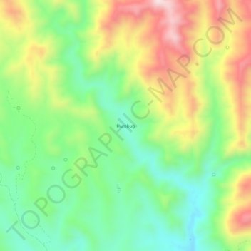
Name: Humbug topographic map, elevation, terrain.
Location: Humbug, Yavapai County, Arizona, United States (34.03444 -112.34313 34.07444 -112.30313)
Average elevation: 875 m
Minimum elevation: 673 m
Maximum elevation: 1,169 m
Other topographic maps
Click on a map to view its topography, its elevation and its terrain.
Prescott
United States > Arizona > Yavapai County
Prescott is in the Bradshaw Mountains of central Arizona, at an elevation of 5,400 feet (1,600 m). The city has a Mediterranean climate (Köppen Csa) bordering on a Humid subtropical climate (Köppen Cfa); however, unlike most other locations in this climate class, there is a pronounced summer wet season due…
Average elevation: 1,674 m