
Watauga County topographic map
Interactive map
Click on the map to display elevation.
About this map
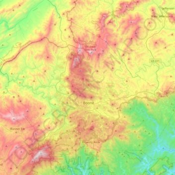
Name: Watauga County topographic map, elevation, terrain.
Location: Watauga County, North Carolina, United States (36.11147 -81.91812 36.39129 -81.45580)
Average elevation: 984 m
Minimum elevation: 378 m
Maximum elevation: 1,777 m
Watauga County is extremely mountainous, and all of the county's terrain is located within the Appalachian Mountains range. The highest point in the county is Calloway Peak, the highest peak of Grandfather Mountain (shared with the adjacent counties of Avery and Caldwell), which rises to 5,964 feet (1,818 meters) above sea level. At an elevation of 5,506 feet (1,678 meters) above sea level, Beech Mountain is the highest incorporated community east of the Mississippi River. Boone, the county's largest city and county seat, has the highest elevation (3,333 feet) of any city over 10,000 population in the Eastern United States.
Other topographic maps
Click on a map to view its topography, its elevation and its terrain.
Wake County
United States > North Carolina
Wake County, North Carolina, United States
Average elevation: 96 m
Hickory
United States > North Carolina > Catawba County
Hickory, Catawba County, North Carolina, United States
Average elevation: 317 m
Moore County
United States > North Carolina
Moore County, North Carolina, United States
Average elevation: 127 m
Seven Lakes
United States > North Carolina > Moore County
Seven Lakes, Moore County, North Carolina, United States
Average elevation: 168 m
Highlands
United States > North Carolina > Macon County
Highlands, Macon County, North Carolina, 28741, United States
Average elevation: 1,116 m
Fort Liberty
United States > North Carolina > Hoke County
Fort Liberty, Hoke County, North Carolina, United States
Average elevation: 88 m
Wallace
United States > North Carolina > Duplin County
Wallace, Duplin County, North Carolina, United States
Average elevation: 16 m
Jeffers Lake
United States > North Carolina > Henderson County
Jeffers Lake, Henderson County, North Carolina, United States
Average elevation: 800 m
Mount Pleasant Water Lagoon
United States > North Carolina > Cabarrus County > Mount Pleasant
Mount Pleasant Water Lagoon, Mount Pleasant, Cabarrus County, North Carolina, United States
Average elevation: 203 m
Glen Forest
United States > North Carolina > Durham County
Glen Forest, Durham County, North Carolina, United States
Average elevation: 101 m
Pike Road
United States > North Carolina > Beaufort County
Pike Road, Beaufort County, North Carolina, United States
Average elevation: 4 m
Whispering Pines
United States > North Carolina > Moore County
Whispering Pines, Moore County, North Carolina, United States
Average elevation: 108 m
Franklin
United States > North Carolina > Macon County
Franklin, Macon County, North Carolina, 28734, United States
Average elevation: 675 m
Warrenwood
United States > North Carolina > Cumberland County > Fayetteville
Warrenwood, Fayetteville, Cumberland County, North Carolina, 28311, United States
Average elevation: 64 m
Holly Springs
United States > North Carolina > Wake County
Holly Springs, Wake County, North Carolina, 27540, United States
Average elevation: 115 m
Carthage
United States > North Carolina > Moore County
Carthage, Moore County, North Carolina, United States
Average elevation: 128 m
Hope Mills
United States > North Carolina > Cumberland County
Hope Mills, Cumberland County, North Carolina, United States
Average elevation: 49 m
Roanoke Island
United States > North Carolina > Dare County > Manteo
Roanoke Island, Manteo, Dare County, North Carolina, United States
Average elevation: 1 m
Raleigh
United States > North Carolina > Wake County
Raleigh, Wake County, North Carolina, United States
Average elevation: 103 m
Harriet Cove
United States > North Carolina > Buncombe County
Harriet Cove, Buncombe County, North Carolina, 28707, United States
Average elevation: 919 m
Troutman
United States > North Carolina > Iredell County
Troutman, Iredell County, North Carolina, United States
Average elevation: 276 m
Greensboro
United States > North Carolina > Guilford County
Greensboro, Guilford County, North Carolina, United States
Average elevation: 242 m
Hillsborough
United States > North Carolina > Orange County
Hillsborough, Orange County, North Carolina, 27278, United States
Average elevation: 187 m
Stoneville
United States > North Carolina > Rockingham County
Stoneville, Rockingham County, North Carolina, United States
Average elevation: 223 m
Raleigh
United States > North Carolina > Wake County
Raleigh, Wake County, North Carolina, United States, Drainage for Lafeyette Village
Average elevation: 126 m
Five Points Park
United States > North Carolina > Guilford County > High Point
Five Points Park, High Point, Guilford County, North Carolina, United States
Average elevation: 264 m
Kimberly Acres
United States > North Carolina > Forsyth County
Kimberly Acres, Forsyth County, North Carolina, 27284, United States
Average elevation: 277 m
Wake Forest
United States > North Carolina > Wake County
Wake Forest, Wake County, North Carolina, 27588, United States
Average elevation: 105 m
Horner
United States > North Carolina > Granville County
Horner, Granville County, North Carolina, 27565, United States
Average elevation: 142 m
Taylortown
United States > North Carolina > Moore County
Taylortown, Moore County, North Carolina, United States
Average elevation: 135 m
South Henderson
United States > North Carolina > Vance County > Henderson
South Henderson, Henderson, Vance County, North Carolina, 27536, United States
Average elevation: 144 m
Calvin
United States > North Carolina > Burke County > Morganton
Calvin, Morganton, Burke County, North Carolina, 28655, United States
Average elevation: 327 m
Bladen County
United States > North Carolina
Bladen County, North Carolina, United States
Average elevation: 27 m
Mackay Island
United States > North Carolina > Currituck County
Mackay Island, Currituck County, North Carolina, 27950, United States
Average elevation: 2 m
Edgecombe County
United States > North Carolina
Edgecombe County, North Carolina, United States
Average elevation: 28 m
Newland
United States > North Carolina > Avery County
Newland, Avery County, North Carolina, United States
Average elevation: 1,140 m
Johnston County
United States > North Carolina
Johnston County, North Carolina, United States
Average elevation: 64 m
Ridgecrest
United States > North Carolina > Buncombe County
Ridgecrest, Buncombe County, North Carolina, 28770, United States
Average elevation: 875 m
Garden Homes
United States > North Carolina > Guilford County > Greensboro
Garden Homes, Greensboro, Guilford County, North Carolina, 27408, United States
Average elevation: 265 m
Fuquay-Varina
United States > North Carolina > Wake County
Fuquay-Varina, Wake County, North Carolina, 27526, United States
Average elevation: 113 m
Newton
United States > North Carolina > Catawba County
Newton, Catawba County, North Carolina, 28658, United States
Average elevation: 287 m
Ayersville
United States > North Carolina > Rockingham County
Ayersville, Rockingham County, North Carolina, United States
Average elevation: 289 m
Pennydale
United States > North Carolina > Guilford County > Greensboro
Pennydale, Greensboro, Guilford County, North Carolina, 27407, United States
Average elevation: 260 m
New Bern
United States > North Carolina > Craven County
New Bern, Craven County, North Carolina, United States
Average elevation: 5 m
Wentworth
United States > North Carolina > Rockingham County
Wentworth, Rockingham County, North Carolina, 27375, United States
Average elevation: 222 m
Asheboro
United States > North Carolina > Randolph County
Asheboro, Randolph County, North Carolina, United States
Average elevation: 208 m
Ravenwood
United States > North Carolina > Randolph County > Archdale
Ravenwood, Archdale, Randolph County, North Carolina, 27263, United States
Average elevation: 249 m
Mount Holly
United States > North Carolina > Gaston County
Mount Holly, Gaston County, North Carolina, 28120, United States
Average elevation: 208 m
Cary
United States > North Carolina > Wake County
Cary, Wake County, North Carolina, United States
Average elevation: 111 m
Murry Hill Park
United States > North Carolina > Buncombe County > Asheville > River Arts District
Murry Hill Park, River Arts District, Asheville, Buncombe County, North Carolina, 28801, United States
Average elevation: 639 m