Geolocate

Rowe topographic map

Click on the map to display elevation.

About this map

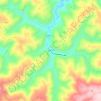
Name: Rowe topographic map, elevation, terrain.

Location: Rowe, Buchanan County, Virginia, 24646, United States (37.11622 -82.05263 37.15622 -82.01263)

Average elevation: 654 m

Minimum elevation: 492 m

Maximum elevation: 848 m

Other topographic maps

Click on a map to view its topography, its elevation and its terrain.

Vansant

United States > Virginia > Buchanan County

Average elevation: 547 m

Gear up for your next adventure:

🏫Topographic World Globes - 3D physical relief globes to understand global geography
🦶Orthotic Hiking Insoles - Extra arch support for long-distance topographic treks
☀️Portable Solar Chargers - High-efficiency panels to hang on your backpack while walking
Altimeter Barometer Watches - Outdoor watches with built-in sensors to track altitude changes and weather shifts
🥶Thermal Beanies - Warm hats for cold hikes

As an Amazon Associate, this site earns from qualifying purchases at no extra cost to you.