Geolocate

Maidenhead topographic map

Click on the map to display elevation.

About this map
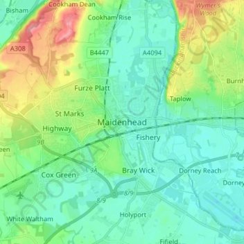
Name: Maidenhead topographic map, elevation, terrain.

Location: Maidenhead, Berkshire, England, SL6 1QB, United Kingdom (51.48274 -0.75974 51.56274 -0.67974)

Average elevation: 41 m

Minimum elevation: 16 m

Maximum elevation: 113 m

Other topographic maps

Click on a map to view its topography, its elevation and its terrain.

Bucklebury

United Kingdom > England > Berkshire

Average elevation: 99 m

Bracknell

United Kingdom > England > Berkshire

Average elevation: 80 m

Reading

United Kingdom > England > Berkshire > Reading

Average elevation: 58 m

Thatcham

United Kingdom > England > Berkshire

Average elevation: 94 m

Midgham

United Kingdom > England > Berkshire > West Berkshire

Average elevation: 90 m

Sonning

United Kingdom > England > Berkshire

Average elevation: 45 m

River Loddon

United Kingdom > England > Berkshire > Winnersh

Average elevation: 68 m

Gear up for your next adventure:

🧼Biodegradable Soap - Eco-friendly outdoor soap
🦟Insect Repellent - Protection against insects
🆘Personal Locator Beacons (PLB) - Satellite emergency beacons for life-saving help in areas with no mobile coverage
🚴Cycling Backpacks - Backpacks for cyclists
📖Australian Bush Survival Books - Local knowledge on finding water and surviving the outback

As an Amazon Associate, this site earns from qualifying purchases at no extra cost to you.